|
The Wireless Sensor Network, established in 2008, on the Springbrook rainforest restoration property, Pallida (2824 Springbrook Road in the Boy-ull Creek Catchment), is a collaborative project involving the Department of Environment and Heritage Protection (EHP), the CSIRO and ARCS. The aim of the project is to provide critical real-time data on the environmental drivers of habitat quality and ecosystem dynamics during rainforest recovery after clearing. Importantly, the project will also potentially provide data on climate change in this World Heritage area.
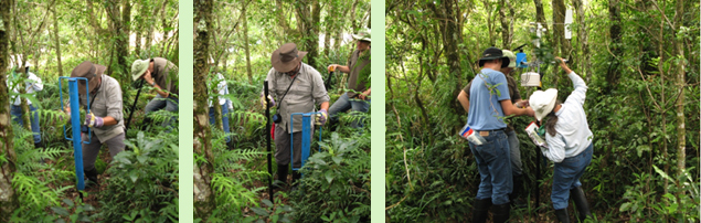
The first 10 nodes were installed in 2008, the next 50 in 2010 and the balance of the final 175 nodes in 2011. Dendrometers and sap flow sensors will be incorporated into the network when manufacturing delays are overcome.
The Springbrook Wireless Sensor Network Project won the Queenlsand iAwards for Research and Development in 2012. The award was presented by the Hon Ros Bates, Minister for Science, Information Technology, Innovation and the Arts.
|
 Dr Gordon Guymer (Queensland Herbarium)(Right) and Darren Moore (Head, Autonomous Systems Laboratory,
CSIRO)(Left) receive the iAward from Hon. Ros Bates at the gala ceremony in 2012. |
The project was initiated by ARCS, funded as a result of ARCS’ initiatives, planned in conjunction with the then Department of Environment and Resource Management (DERM) and CSIRO, and implemented by CSIRO and DERM with ARCS responsible for the deployment design (what sensors, where, when, why) as well as providing ongoing assistance in maintaining 5 km of access tracks (established on over-grown pre-existing tracks), in sensor installation and maintenance, and occasional simple system maintenance.
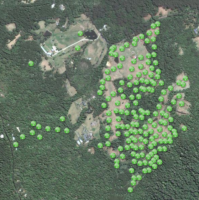
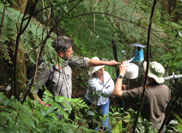
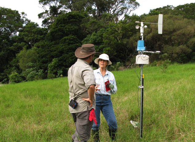
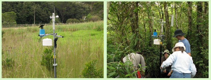
The monitoring system includes a state-of-the art, continuously operating wireless sensor network with 175 nodes and 700 individual sensors providing long-term, catchment-wide micro-meteorological and soil hydrological data (including changes to the cloud base and the degree of cloud immersion). The project allows correlation of climatic, edaphic and physiographic data with plant recruitment, mortality and productivity data at ecologically relevant spatial and temporal scales ranging from microsites to meso-sized catchments over the long term. The design was informed by our ecological conceptual model which underpins consideration of all restoration interventions.
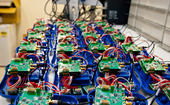
The 175 nodes located across the study site each consist of a mini-computer with several attached sensors. The nodes ‘talk’ to each other such that the data collected from the sensors ‘hop’ using wireless technology from node to node and eventually to a central hub via the most energy-efficient routes. From the hub, the data are transferred via the internet to a ‘super’ database at the CSIRO in Brisbane.
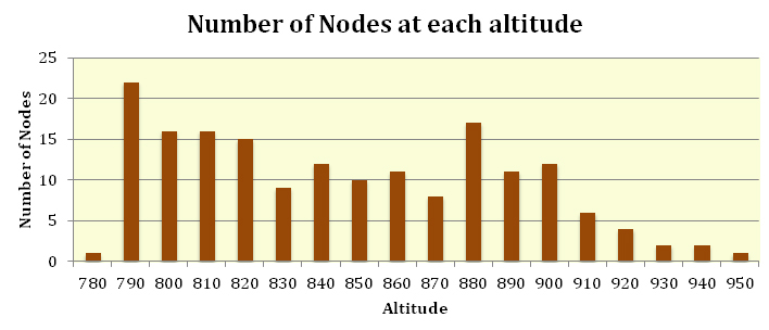
The basic ecological design involved placement of nodes with varying numbers of sensors per node at 50-metre intervals along each 10-metre contour ensuring replicated sampling of differences in aspect and quality and quantity of vegetation cover. There are at least five or more nodes at each contour interval from 790m to 910m (See Chart below.). Forty per cent of nodes are in cleared areas, 30% at forest edges and 30% are within regenerating forests. ARCS recommended the type, number and placement of sensors in the system to most usefully and feasibly guide and monitor restoration. Costs of different sensors constrained the numbers that could finally be deployed. Engineering design and data storage are the responsibility of the CSIRO. All nodes measure basic parameters of air temperature, relative humidity, leaf wetness and soil moisture. These are complemented by additional sensors that measure rainfall, solar radiation, wind speed and direction, barometric pressure, cloud immersion, carbon dioxide levels and soil water potential. With an average of five variables recorded at each of the 175 sensor nodes every five minutes, 252,000 observations are recorded and transmitted to the central node (sink) each day, or over 90 million each year. This represents challenges for sampling, storage and analysis that are being overcome by CSIRO.
Thus, as all wireless sensor networks are constrained by energy, communication bandwidth, transmission range, and storage capacity, the Springbrook deployment provides an excellent research test bed to improve the design of networks in order for the transformational potential of this environmental monitoring technology to be fully realized.
A separate battery-powered, Wireless Multimedia Sensor Network (WMSN) monitors animal movements and sounds. This audio and video recording program will be particularly valuable in monitoring the recovery of faunal habitat.
A brochure on the Wireless Sensor Network can be downloaded here.
Links
EHP: http://www.ehp.qld.gov.au/plants/herbarium/wireless_sensor_network_springbrook.html
CSIRO http://research.ict.csiro.au/research/labs/autonomous-systems/sensor-networks/sensor-networks
|
Sensors currently in place measure —
- Air temperature (from ground level to several metres high)
- Relative humidity
- Barometric pressure
- Rainfall
- Solar radiation
- Photosynthetically active radiation (PAR)
- Leaf wetness
- Wind speed and direction
- Cloud ceiling height
- Fog density during cloud immersions
- Carbon dioxide levels
- Soil moisture
- Soil water potential
Additional sensors will include sap-flow sensors and dendrometers to automatically monitor and correlate plant growth and water use.
Springbrook is an ideal testing platform for this state-of-the-art technology because of the sharp environmental gradients (e.g. 200–1050 m altitude, 1800 to >3500 mm annual rainfall, leached skeletal soils to deep, nutrient rich basalt-derived soils) within a relatively small area of complex terrain.
Results will start to be published in peer-reviewed journals when sufficient, statistically robust data are accumulated. |
|
References
Hu, W., Corke, P., Hodge, J., Keto, A., Mackey, B., Foley, G., Sikka, P. and Brunig, M. (2008). Intelligent sensors, sensor networks and information processessing. ISSNIP 2008. International conference on Topic(s): Communication, Networking and Broadcasting; Components, Circuits, Devices and Systems; Computing and Processing (Hardware/Software); Signal Processing and Analysis.
Moore, D. and Chamberlain, D. (2011). Rainforest rehabilitation underpinned by smart CSIRO technology: One of the world’s largest wireless sensor networks is revolutionising environmental monitoring and biodiversity restoration. www.csiro.au/en/Outcomes/ICT-and-Services/National-Challenges/rainforest-rehabilitation.aspx
Toscas, P.J., Garcia-Flores, R. and Dae-Jin, L. (2011). Wireless sensor networks and the statistical sciences. http://isi2011.congressplanner.eu/pdfs/450204.pdf
Wark, T., Hu, W., Corke, P.I., Hodge, J., Keto, A., Mackey, B., Foley, G., Sikka, P. and Brunig, M. (2008). 4th International Conference on Intelligent Sensors, Sensor Networks and Information Processing (ISSNIP 2008), Sydney, NSW, 2008. ISSN/ISBN: 9781424429561. |