| Home | The Vision | Springbrook — A Natural Wonder | The Springbrook Rescue Project | Support the Project | About ARCS |
Menu
Springbrook’s Climate Palaeoclimates Climate exerts a dominant control over the distribution of species such that the presence or absence of characteristic species in the fossil record is a reliable indicator of ancient palaeoclimates. More than 30 million years ago, climates were warmer, wetter and more equable. There have been catastrophic climatic collapses over the millennia causing mass extinctions. Yet some plant and animal lineages dating back to the earliest stages in the earth’s evolutionary history still miraculously survive relatively unchanged. These are called β-clades. Their survival centres, or climate refugia, are microcosms of stable local “microclimates” buffered by intact canopies against the inhospitable extremes of current “macroclimates” around them that are significantly out of phase with the ancient palaeoclimates in which the old lineages evolved. Breaking this buffering by clearing for farms and towns and fragmentation from roads, powerlines and house lots exposes ancient wildlife lineages to increasingly unpredictable climatic extremes to which they are not adapted. Conditions will only deteriorate further under predicted climate change of higher average temperatures, less rainfall and more variable and extreme weather events.
| ||
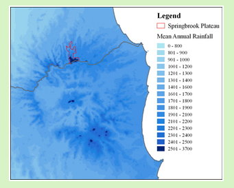
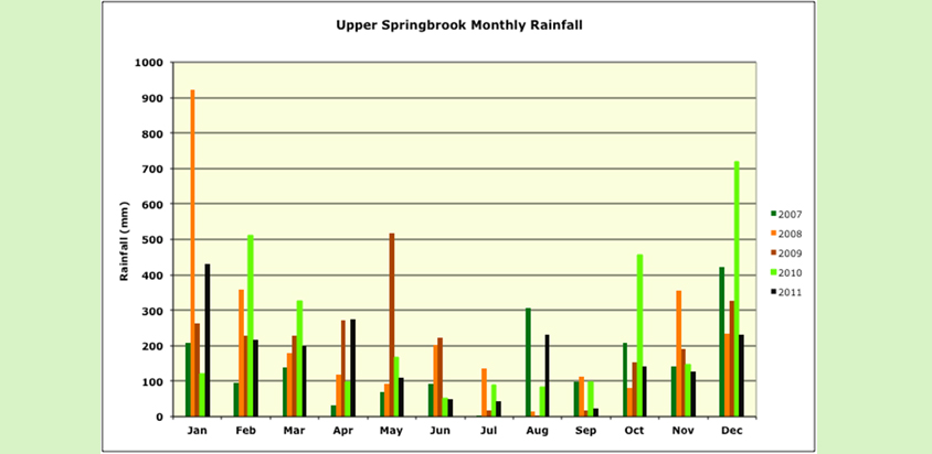
Current climate In contrast to palaeoclimates which were warmer, wetter and more equable, today’s climate is subtropical, moist maritime, characterized by warm, wet summers and cool dry winters, with considerable interannual variability. Unstable moist air masses flow from the east in summer and dry westerlies dominate in winter. Mean annual temperature is ~ 15°C with a monthly average maximum of ~ 27°C and a minimum of ~ 3°C. January is hottest, and August the coldest month. Frosts are possible at any time of the year, hailstorms occur annually but snow is very rare with recorded incidences in 1948 and 1985. The Springbrook Plateau is the wettest area on mainland Australia outside the Wet Tropics. Mean annual precipitation exceeds 3500 mm at higher altitudes, with marked interannual variation in both seasonal and annual levels related to El Niño Southern Oscillation (ENSO) events and East Coast Lows (ECLs). Most rain falls between December and April with February the wettest month (475 mm average). August to September are the driest with generally less than 100 mm of precipitation per month. A 1600-mm isohyet skirts the base of the plateau. |
 |
|
 |
||
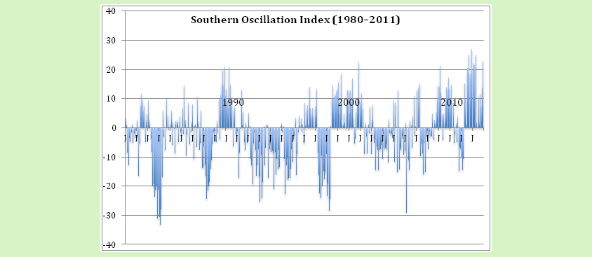
East Coast Lows (ECL) These are intense, but short-duration low-pressure systems especially during Autumn and Winter but peaking in June They develop more frequently off-shore between 25°S and 40°S latitude from southern Queensland to eastern Victorian, in the wake of cold fronts moving across southern Australia and/or sea surface temperature (SST) gradients associated with warm eddies of the East Australian Current. Strong to gale-force winds and extensive, heavy to flooding rain result south of a low’s centre. They tend to cluster, with up to one third of all events occurring within three weeks of a preceding episode. El Niño Southern Oscillation (ENSO) The El Niño Southern Oscillation (ENSO) is associated with climate variability over millennial, decadal and interannual (two- to seven-year) cycles, and the resulting alternating periods of drought that can last six to 18 months or several years have a profound impact on species and genetic diversity and vegetation dynamics, especially where productivity is limited by water availability. These cycles have important implications for ecosystem restoration, especially if human-induced climate is altering the nature and underlying mechanisms of El Niño events. ENSO activity is linked with an increased polar-equator atmospheric gradient driven by temperature changes in the tropical Pacific Ocean. The Southern Oscillation Index or SOI published by the Australian Bureau of Meteorology (BOM) provides up to 18 months warning of changes in intensity and frequency of these critical events. Sustained positive values of the SOI greater than +8 are typical of a La Niña episode (cooler, wetter), whilst sustained negative values of the same magnitude reflect an El Niño event (warmer drier). In the last 30 years (1980–2011), La Nina events occurred first at ~10 year intervals then increased in frequency (1988-89, 1998-2001, 2007-08, 2008-09, 2010-2012). In comparison, drier, warmer conditions, persisting over longer periods, existed by far the greater proportion of time over the same interval. |
||
 |
||
Implications of seasonality and variability of rainfall and temperatures Rainfall seasonality and variability regulates plant diversity and density by affecting plant available moisture and shade tolerance, thus the number of different plant functional types able to persist. Plant available moisture and light are the critical climatic determinants of plant growth and hence site productivity. Ancient plant lineages, with conserved physiological traits adapted to wetter, more equable conditions than at present, trying to colonise large clearings under today’s climates face considerable barriers to successful establishment and persistence. Overcoming these barriers will be one of the great challenges for restoring and protecting World Heritage biota on the Springbrook Plateau. Recent evidence points to the importance of facilitation or “nurse” effects by modern plants on the regeneration of ancient lineages in today’s seasonally drier climates. |
||