A refugium Map of High Country
A Refugium
Springbrook acts as a critical refugium for ancient lineages of plants and animals that might not otherwise survive modern day conditions. Refugia are mostly found in deep gorges or mountainous areas that are climatically, topographically and edaphically buffered.
Seven critically important buffers of the refugium at Springbrook include:
- maritime influences resulting from proximity to the coast;
- frequent cloud immersion resulting from
- the higher altitudes,
- existence and orientation of vertical cliff faces that catapult and cool south-easterly moisture-bearing winds upwards, and
- intact rainforest canopies that generate cloud-seeding aerosols then strip those clouds of moisture. Cloud immersion augments rainfall by up to 50 percent or more but is threatened by climate change and clearing of rainforests;
- underground aquifers arising from fractured basalts that seep extra moisture out to surface soils of slopes; these aquifers, together with the wetter microsites created are extremely vulnerable to ground-water extraction; co-occurring rare or vulnerable species such as Triunia youngiana, Ardisia bakeri, Symplocos baeuerlenii, and Psychotria simmondsiana may depend on these perhumid microsites for their survival;
- Hydraulic redistribution or “water banking” by deep-rooted forest canopy trees that, through the roots of tall emergent trees, redistribute moisture between shallow and deeper soil layers to ameliorate impacts of dry periods;
- closed forest canopies that (a) emit cloud-seeding aerosols, (b) store and recycle critical nutrients otherwise lost by leaching of soils, and (d) seal moister and cooler microclimates more akin to ancient palaeoclimates;
- topographic diversity or rapid changes in altitude, slope and aspect over short distances, increasing habitat diversity and reducing distances plants and animals have to travel to track climate change; forest fragmentation from clearing destroys this buffering by breaking habitat linkages;
- geographic isolation and stability that preserves ancient lineages from being genetically swamped by modern biota. These “sky islands” are biogeographic isolates in the same way as true islands off shore.
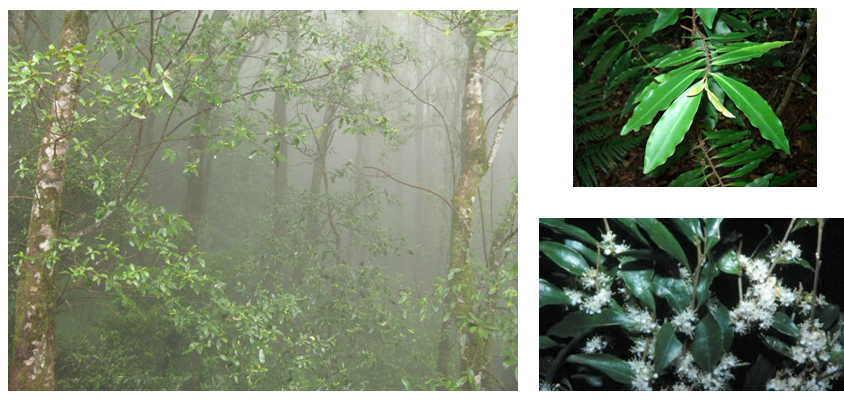 |
| Cloud forest at 900 metres at Springbrook |
Top: Ardisia bakeri |
| Bottom: Symplocos baeuerlenii |
 |
The image on the left, from Google Earth, looking towards Springbrook from the east, shows the plateau bordered on the south and east by clifflines that force moisture-bearing south-easterly winds sharply upward producing the highest rainfall on the continent outside of the Wet Tropics of northern Queensland.
The coastline is only about 20 km from the foreground in the image on the left.
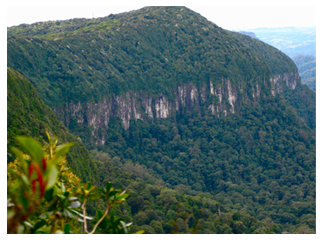
Cliffline at the southern edge of Springbrook Plateau seen from Best-of-All Lookout |
|
|